If you've been a resident west of the Appalachian Mountains (especially in the foothills) and enjoy watching the weather, it's likely that you've heard your favorite meteorologist describe the unique event called, "Cold Air Damming." Effects can include increased northerly winds, anomalously cold surface temps, and rain (packaged with yucky dreariness). It can even make the difference between seeing wintry-weather or a cold, drenching rain.
In meteorology, we have many acronyms to help save time (and twitter characters) typing. For the duration of this write-up, I'll refer to it as CAD. In addition, I'll be focusing on the Carolinas, but know CAD can occur along many major, elongated mountain ranges,
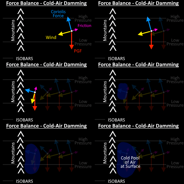
In essence, the name clues you in on what is happening: Cold air is dammed by the respective mountain range. As air is a fluid, it's fine to think of it analogously to water and a reservoir. What's happening to the air is that the mountains are changing the dynamics of the fluid's flow. Typically, an area of surface high-pressure causes generally cooler (and thus, denser) air to intrude from the north.
In addition to friction, topography acts to slow down the air (the wind).

This weakens the apparent Coriolis Force. Therefore, this force disruption is created/magnified and allows the Pressure-Gradient Force (PGF) to dictate wind-direction.
I like to think of it as terms of mass build-up. The force-disruption seen inhibits momentum. Thus the cool air collects and builds up against the mountains (more on that reasoning in a minute). Thus mass, density, and advecting cold temperatures accumulate.

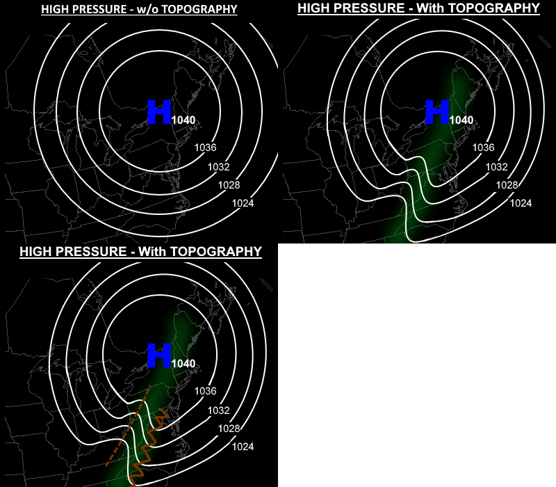
On analysis maps, a resulting signal is ridging, or an extension of high-pressure. Similar signatures will be observable in the temperature and dew-point (moisture) gradients.
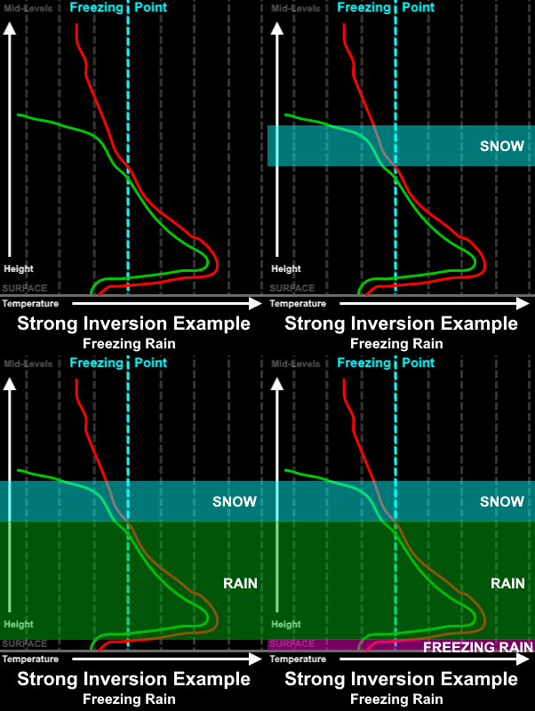
Another key mechanism to CAD is an inversion. Rather than temperatures cooling with height, they can actually warm with height. Although very typical at night-time in most mid-latitude locations, simply eroding away during the day from low-level heating, CAD allows inversions to stay in place for days.

Within the cold dome of air, little rising occurs as the vertical change in density (temperature; the inversion) hinders the ability of overcoming topography. Although the air would like to be continuous in flow and go over the mountain, insufficient forcing exists for the air to have the needed momentum. So it gets boxed in from above; favoring the collecting over time and increasing the density and the advecting northerly cool air.
Moisture (typically within air which is more unstable), which incurs less interference from the mountains can be easily forced upward by a CAD event and produce rain. Here in North Carolina, moist-air off of the outer-banks, from over the ocean off of Georgia's coast, or from the Gulf of Mexico are common sources of significant moisture, leading to long periods of dreariness and rain. In the winter, when most they occur, CAD events can effect what kind of precipitation is reaching the ground or what it does when it makes contact with the surface (revisit the above graphic). In addition, although improvements have been made over time, computer models that forecasters use can underestimate the strength of a CAD event.
For you to observe what happens in the lower-levels, and to show just how shallow CAD events are, below is an overview of a recent (Nov. 2017) CAD event.
SOURCES
UCAR MetEd: https://www.meted.ucar.edu/mesoprim/cad/webcast/frameset.htm
WxCory (it reminded me that I should cover inversions): https://www.wxcory.com/single-post/2017/11/08/The-Carolina-Wedge-Cold-Air-Damming


No comments:
Post a Comment